A Map of the Atchafalaya, with the area of its delta in the circle.
Indeed, at its source, the Atchafalaya River actually takes the full volume of the Red River (the same Red River that forms the Texas-Oklahoma state live and upon which Shreveport and Alexandria, Louisiana sit) and 30% of the volume of the Mississippi River. The flow from the Mississippi River is controled by a series of US Army Corps of Engineer maintained dams and levees in Concordia Parish, Louisiana known as the Old River Control Structure. It is thought that without the management of the Corps of Engineers, the main channel of the Mississippi would soon shift into the Atchafalaya, leaving Baton Rouge and New Orleans as backwaters! Here is the website of that facility: US Army Corps of Engineers Old River Control webpage

An aerial view of the Old River Control Structure, with the Mississippi River running to the left (with the riverboats), and three branches, governed by dams, allowing flow over to the Atchafalaya. The Red River is completely out of view the right discharging its entire volume directly into the Atchafalaya.
Just downstream from this beginning of the Atchafalaya and end of the Red River, there is the famous Morganza spillway, a point on the Mississippi that allows extra volume from that river to be spilled over into the Atchafalaya basin and river. That spillway has been used twice since its construction: in 1973 and in 2011. Here is a link to a video of the opening of the Morganza Spillway in May 2011: http://www.cbsnews.com/video/watch/?id=7366074n

Diagram of the Water Travel Times down the Morganza Floodway.
The Corps of Engineers have a great video on flood control in this area and the Morganza Spillway: http://www.mvn.usace.army.mil/pao/videos/morganza/morganza.asp
It is soon after the area of the spillway that the river enters the Atchafalaya Basin, a massive forested-swamp that is familiar to anyone who as driven on I-10 between Lafayette and Baton Rouge, LA. It is currently protected as the Atchafalaya National Heritage Area. There website can be found here: http://www.atchafalaya.org/

A view of part of the Atchafalaya Basin in Louisiana.
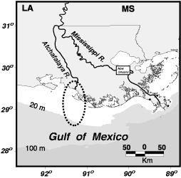
Finally, the Atchafalaya empties into the Gulf of Mexico near Morgan City, Lousiana, presenting a second major delta on the Gulf in the Pelican state. Like the Mississippi River, the Atchafalaya's sediment plumes can be seen out into the Gulf.

Aerial view of the Atchafalaya River delta.
Live well!
Wonderful photos and History, unfortunately all the video and other links on the page are all broken and no longer active.
ReplyDelete