Saturday, October 19, 2013

150th of the Battle of Buckland Mills

Buckland Tavern Photo, Click for full size
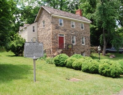
Buckland Tavern, on the Broad Run and VA29 [Lee Highway] in Gainesville, Virginia: one end of the Battle of Buckland Mills -- the other being Warrenton, Virginia.


Today is the 150th Anniversary of the Battle of Buckland Mills, Virginia.  With 12,000 troopers involved, it has been described as the "Last large-scale Confederate cavalry victory in Virginia."

File:Bristoe Campaign.png
Map of the Bristoe Campaign, October-November 1863.  Notice the Battle of Buckland Mills in the top center of the troop movements. [Drawn in Adobe Illustrator CS6 by Hal Jespersen. Graphic source file is available at http://www.cwmaps.com/]

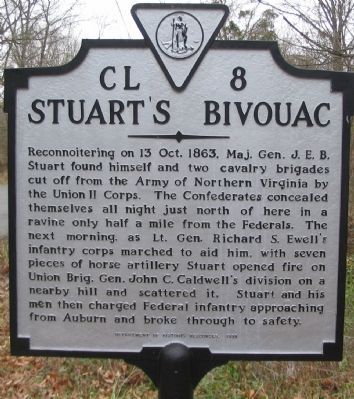
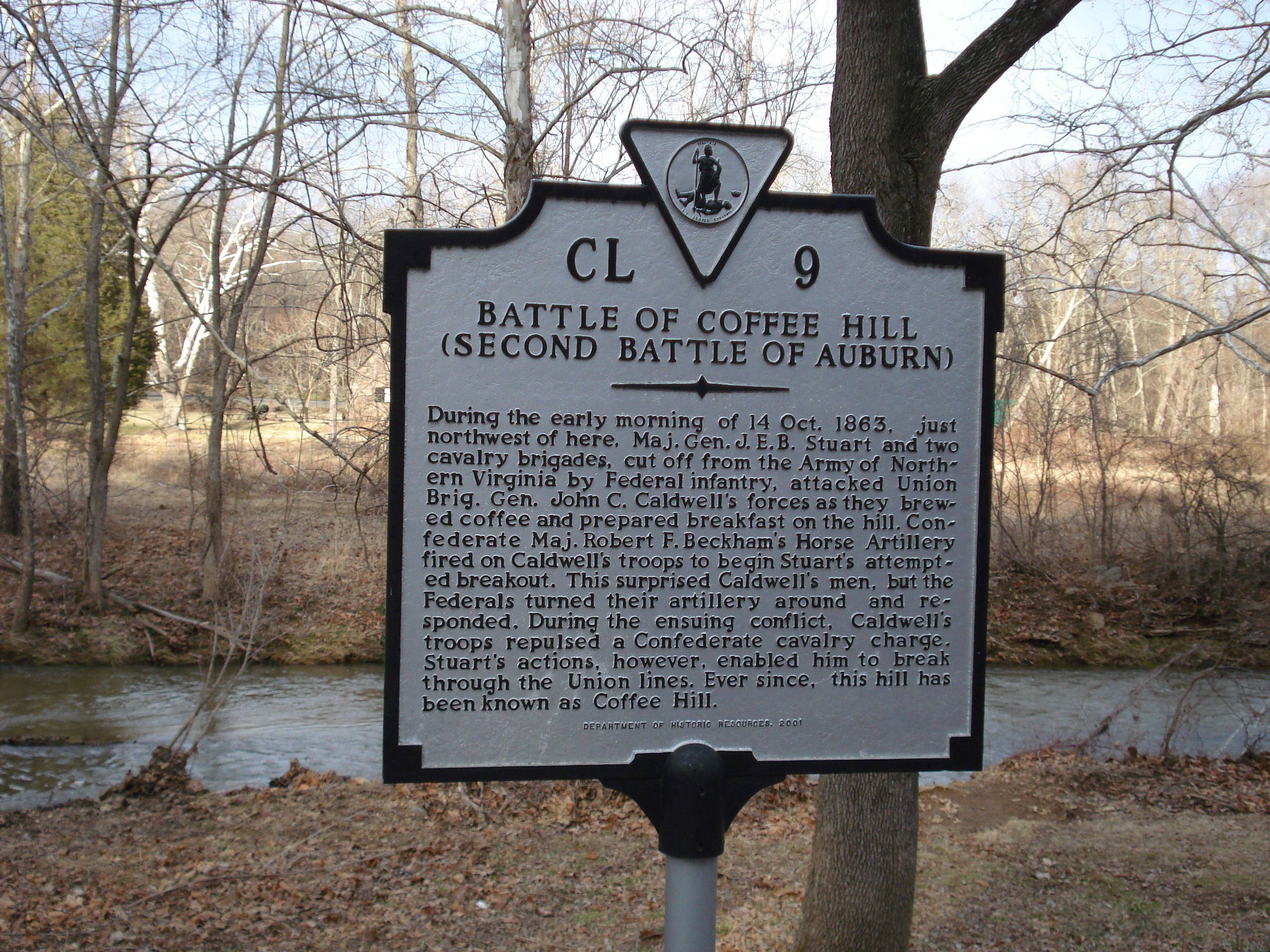
This cavalry engagement was fought in the closing moves of the Bristoe Campaign.  The failed attack of CS General A.P. Hill on the retreating Union Army of the Potomac at Bristoe Station on 14 October 1863 only confirmed the fact that US General Meade had succeeded in slipping away from the trap of CS General Robert E. Lee.

File:Meade and Lee.jpg
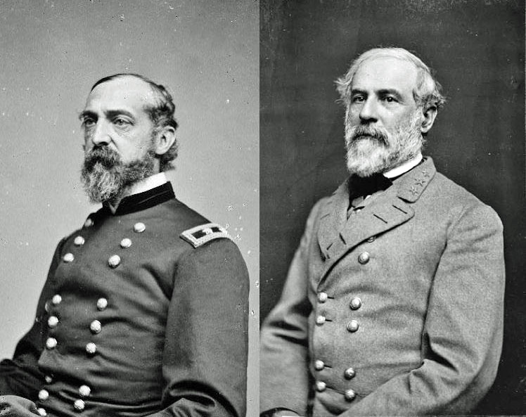
Rivals of the Bristoe Campaign: George Meade and Robert E. Lee.

Meade and the Union Army of the Potomac took up a strong position at the heights of Centreville, beyond the Bull Run.  While Lee and his Confederate Army of Northern Virginia advanced as far as Manassas, it became clear that this was not a tenable position.

Robert E. Lee determined to withdraw to the safety of Virginia south of the Rappahannock River.  The Southern cavalry of CS Major General J.E.B. Stuart would be tasked with screening this withdrawal.

Custer Bvt MG Geo A 1865 LC-BH831-365-crop.jpgJeb stuart.jpg
On the same battlefield: George A. Custer & JEB Stuart.

In this context, on 19 October 1863, along the Warrenton Turnpike (now US29, Lee Highway), in the vicinity of the Prince William-Fauquier County line, a cavalry engagement took place: the Battle of Buckland Mills.

Initially, J.E.B. Stuart and his troopers, however -- the division of Wade Hampton -- fell back from Gainesville towards Warrenton and drew the rest of the Union cavalry of US General Kilpatrick into a trap.  Stuart knew that his troopers would have the additional help of the division of CS General Fitzhugh Lee arriving from the south on the Union flank by way of what is now Rouges and Vint Hill Roads.

Bucklland Races Marker
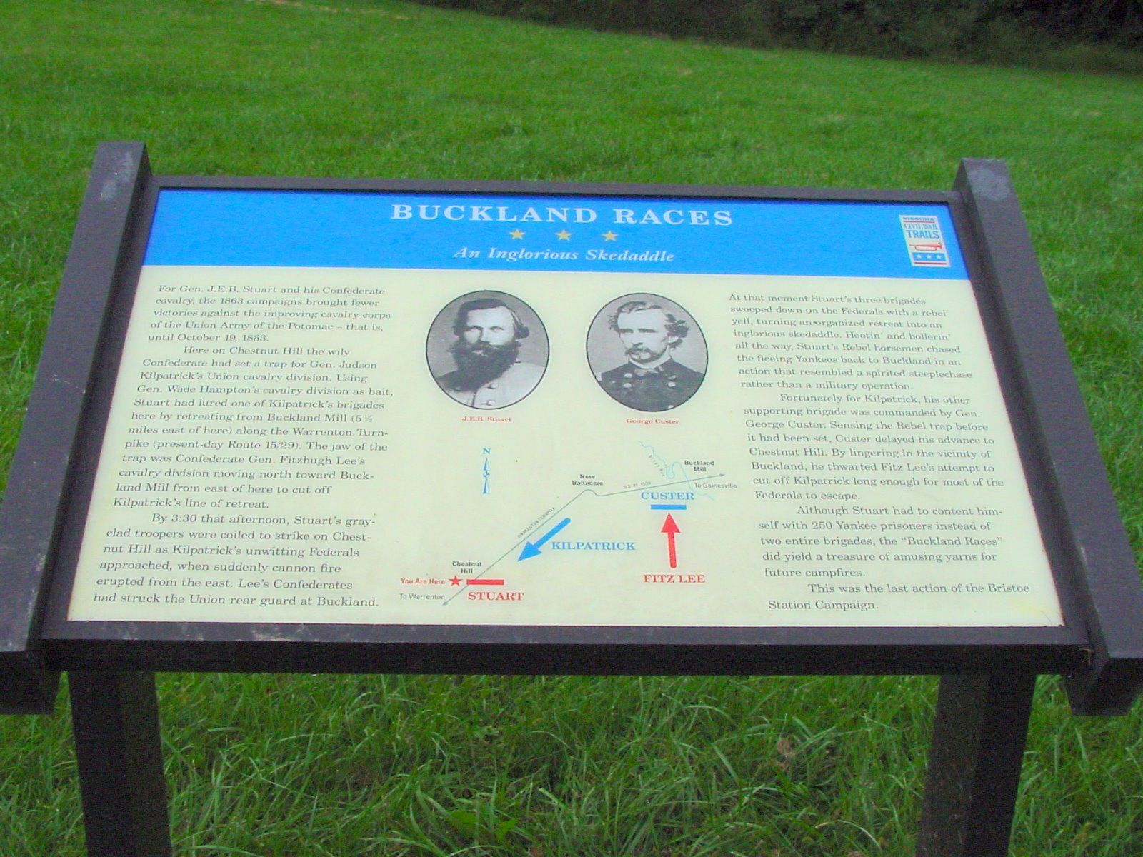
Historical Sign for the Battle of Buckland Mill (or "Buckland Races") located near Chestnut Hill at the park and ride lot on US29 just north of Warrenton, Virginia. [http://www.hmdb.org/marker.asp?marker=784]

So it was that the Southern cavalry fell back to the area of Chestnut Hill (the US29 [Lee Highway] and VA605 [Dumfries Rd.] intersection right outside Warrenton), when Stuart turned his force back and routed the Union troopers -- the brigade of US General Henry Davies, part of Kilpatrick's force.  The pursuit was likened to fox hunting, and the Confederate cavalry referred to it as the Buckland Races.

The Union horsemen fled five miles to the area of Haymarket or Buckland Mills on the Broad Run, just inside Prince William County.  Although the losses were relatively light, it was an embarrassing defeat for Kilpatrick and pushed the Union cavalry far from Robert E. Lee's army.

Buckland Mills Battle Marker
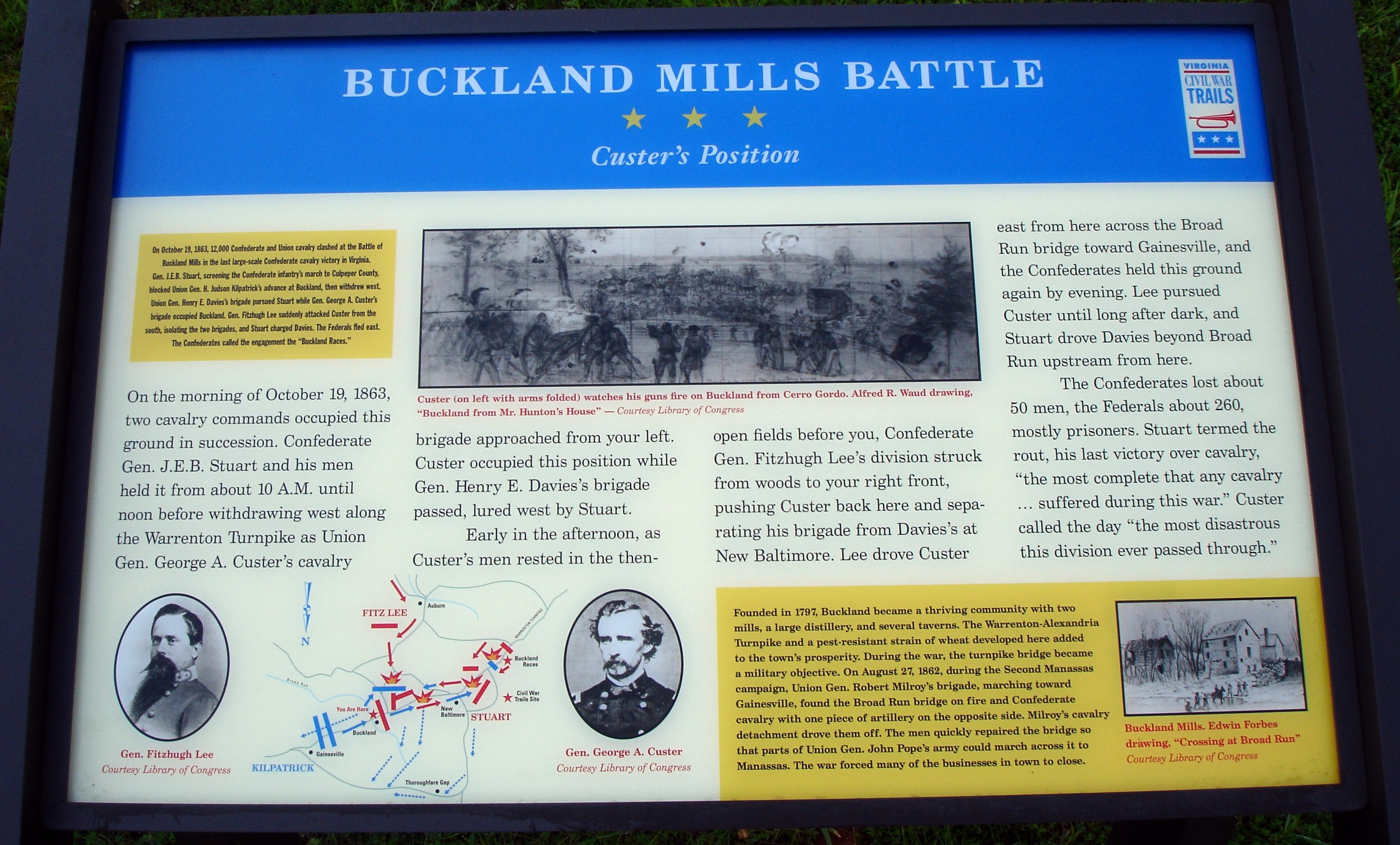
The Historical Sign at Buckland, the other end of the battle corridor along US29 (Lee Highway.) [http://www.hmdb.org/Marker.asp?Marker=19785]

Meanwhile, back near Buckland Mills, the force of CS General Fitzhugh Lee did arrive on the flank, but was blocked by the Union brigade of George A. Custer (of Little Bighorn fame!) along what is now VA215 [Vint Hill Rd.] near its intersection with US29 [Lee Highway] and in the vicinity of Buckland Mills.  Custer and his brigade would be pushed back across the Broad Run, but remained intact.

Perhaps some of my good readers commute this battlefield each day?

This is a great summary from the Civil War Daily Gazette:
http://civilwardailygazette.com/2013/10/19/pell-mell-in-great-disorder-and-confusion-the-buckland-races/?fb_source=pubv1

Here is the NPS description:
http://www.cr.nps.gov/hps/abpp/battles/va042.htm

Live well!

Monday, October 14, 2013

Battle of Bristoe Station 150th Anniversary

Battle of Bristoe Station Marker
Historical Marker at the site of the Battlefield in Bristow, Prince William County, Virginia (cf., http://www.hmdb.org/marker.asp?marker=782)

Today is the anniversary of the Battle of Bristoe Station.  This battle, fought on 14 October 1863, wherein the Confederate Corps of CS General A.P. Hill attempted to shatter the II Corps of US General Warren as it marched along the Orange and Alexandria Railroad.  This attack came as a part of the larger movement of Lee's Confederate Army of Northern Virginia which was attempting to get around the right flank of US General George Meade's Army of the Potomac.  Both armies were depleted of men who had been sent to participate in the campaigns of the West.

The Union Army of the Potomac fell back along the Orange and Alexandria Railroad with the advance of Lee -- and on this day, its II Corps was attacked by Hill's men striking from the west just south of Broad Run.

File:Bristoe Campaign.png
Map of the Bristoe Campaign, October-November 1863. [Drawn in Adobe Illustrator CS6 by Hal Jespersen. Graphic source file is available at http://www.cwmaps.com/]

A.P. Hill's attack, however, would be a dismal failure, and Warren's II Corps repulsed him with relative ease.  The casualties: Union 540 to Confederate 1,380.  In addition, the Union line held, and the Southerners were unable to block a Union withdrawal back towards Washington, DC and the high ground of Centreville, Virginia.  With the Army of the Potomac perched up at Centreville, Lee had little choice but to fall back.  The Bristoe Campaign was not the success he had hoped.  It is also little known owing to the inconclusive outcome.

Also on this day, Stuart's cavalry fought at Auburn/Coffee Hill in the early hours -- a skirmish featured in my post of last Saturday:

You might also note regarding Bristoe Station:
The official website of the Bristoe Station Battlefield, which is a park of Prince William County, Virginia: http://www.pwcgov.org/government/dept/publicworks/hp/Pages/Bristoe-Station-Battlefield.aspx

Well worth the while of anyone living in the area is this new audio tour of the campaign:
http://myoncell.mobi/17033342544

NPS Battle Description: Bristoe Station

Finally, Civil War Daily Gazette Account of 14 October 1863

Live well!

Saturday, October 12, 2013

Auburn (Coffee Hill) 150th Anniversary

Tomorrow is the 150th Anniversary of the First Battle of Auburn.  This clash marked some of the initial contact between the Confederate Army of Northern Virginia and the Union Army of the Potomac in the October 1863 Bristoe Station Campaign.

File:Bristoe Campaign.png
Map of the Bristoe Campaign, October-November 1863. [Drawn in Adobe Illustrator CS6 by Hal Jespersen. Graphic source file is available at http://www.cwmaps.com/]

In the wake of Gettysburg, and both of the contending armies returning to Virginia, each side had detached troops to contribute to the campaign in the West -- the battles of Chickamauga and Chattanooga both saw men involved who had been campaigning in the Eastern Theatre.

CS General Robert E. Lee, who had been in Orange County, Virginia with his Army of Northern Virginia, saw an opportunity to march around the Union Army of the Potomac, commanded by US General George G. Meade, and situated in Culpeper County, Virginia.

Stuart's Bivouac Marker Photo, Click for full size
Historical sign just south of Auburn around the site of the First Battle of Auburn.

Lee was trying to march his force around the Union by going around them to the west -- departing on 9 October 1863, they were soon in Warrenton, Virginia.  This movement forced Meade and the Union army to fall back down along the line of the Orange and Alexandria Railroad.  On 13 October 1863, "Stuart, with Fitzhugh Lee and Lomax’s brigades, skirmished with the rearguard of the Union III Corps near Auburn. Finding himself cut off by retreating Federal columns, Stuart secreted his troopers in a wooded ravine until the unsuspecting Federals moved on." [cf., http://www.cr.nps.gov/hps/abpp/battles/va039.htm]

You might also note this account: Civil War Daily Gazette Account of 13 October 1863

Battle of Coffee Hill Marker
Historical Marker at the location of the Second Battle of Auburn (Coffee Hill), 14 October 1863.  You can see the Cedar Run behind the sign.  (cf., http://www.hmdb.org/marker.asp?marker=2437)

The next day, 14 October, Stuart and his men, cut off from Lee at Warrenton, decided to hack their way through the Union troops in their way during what is known as the Second Battle of Auburn -- surprising these Federal men during breakfast and upending quite a number of Coffee Pots -- hence the alternative name for this battle: Coffee Hill (cf., http://www.cr.nps.gov/hps/abpp/battles/va041.htm)

Recently, a driving tour of the locations of this campaign has been organized -- it is well done, and worth your time: http://myoncell.mobi/17033342544  The tour begins in Warrenton, Virginia.

On Monday, we shall note the main battle of the campaign: Bristoe Station.

Live well!

Saturday, October 5, 2013

Lord Fairfax and his Proprietorship

Lord Fairfax Marker Photo, Click for full size

Recently, this blogger and his family took a journey from the County of Fauquier north along the old Winchester Road to the city of like name: Winchester, Virginia.

File:ThomasFairfax6th.jpg
Thomas, 6th Lord Fairfax of Cameron.

All of the counties along this route once belonged to the Proprietorship of Lord Fairfax.  Thomas Fairfax, 6th Lord Fairfax of Cameron (+1781AD), was the inheritor of a vast proprietary claim that included the colony of Virginia north of the Rappahannock River.  This had been a gift to loyal supporters of King Charles II, and Fairfax's mother, a Culpeper, had come into possession of the bulk of the territory.  It was this family that employed the Carters as land agents in Northern Virginia.  When Lord Fairfax, born in 1693AD at Leeds Castle in England, inherited this holding, he was not a disinterested proprietor, but actually visited Northern Virginia in the 1730s, moved to Belvoir on the Potomac with his cousin in 1747, and established his residence in the Shenandoah Valley at Greenway Court in 1752.  This bachelor peer was a benevolent proprietor who was willing to work with his subjects when it came to their property taxes, at least more willing than the government of the colony.  Fairfax County would be named in his honor in 1742AD (formed from Pr. Wm. Co.).  While he remained loyal to the crown during the Revolution, he was well respected enough to be left alone.  He died in 1781 at a ripe old age.


Map of the Northern Neck Proprietorship, 1736/1737.

The Proprietorship of the Northern Neck was dissolved with the Revolution, but his private lands remained in the control of his heirs -- who sold them to a group of gentlemen led by John Marshall, who would become chief justice of the Supreme Court.

I present then, a couple of shots of the tomb of Lord Fairfax himself in Winchester, Virginia.


The marker on the top of the tomb was, unfortunately, waterlogged from a recent rain.  The tomb is located in a courtyard next to Christ Episcopal Church on Boscawen Street.  These two following shots provides some context:


Only a couple blocks away is the very heart of the City of Winchester -- a city that was a frontier town and military staging point during the French and Indian War (Seven Years' War) in the 1750s.


Aside from the lovely pedestrian area downtown, Winchester is also the home of the old Frederick County courthouse.  Frederick was one of the two original Virginia counties formed west of the Blue Ridge.  An example of the architecture of the city is this, the Godfrey Miller home, built in 1785 and located downtown (cf., http://www.hmdb.org/marker.asp?MarkerID=60607):


On our journey, passing as we did from the Virginia Piedmont into the Shenandoah Valley of Virginia, we had, of necessity to cross the Blue Ridge mountain.  We did so at the Ashby Gap.  Ashby Gap happens also to be the point where the boundary line between the County of Loudoun and the County of Fauquier, Virginia ends -- beginning at the headwaters of the Bull Run to the east.  That spot was originally marked by, as the colonial law forming the new county put it: "from the head of the main branch of Bull Run, by a straight course to the Thorough-fare of the Blue Ridge of mountains, known by the name of Ashby's Gap."  The point in Ashby Gap where this line was to begin was originally marked by a tree.  Now, you find the convergence point of Loudoun, Fauquier, and Clarke Counties, Virginia marked by this stone (the ridge also marks the eastern edge of Valley counties such as Clarke).  US 50 and 17 come that close to entering Loudoun County!


Live well!

Tuesday, October 1, 2013

Music of Colonial Latin America

Too much neglected is some of the gorgeous music of colonial Latin America -- especially its Renaissance-style polyphony and Baroque works.

In this post, I simply wish to present a brief collection of some of the more impressive works that I have heard -- along with imagery of the architectural and artistic treasures of the Spanish and Portuguese New World.

I shall start in the north, in the old Viceroyalty of New Spain, and proceed south.

SPANISH VICEROYALTY OF NEW SPAIN

File:Nueva España 1795.png
The Viceroyalty of New Spain at its geographical greatest extent

The Spanish-born Hernando Franco (+1585AD) who was musically active in Guatemala and Mexico is certainly one of the most impressive composers writing in the New World.  His is the style of Renaissance polyphony -- a la Tomas Luis de Vittoria.  Here is a setting he wrote of the Salve Regina; worthy of note, too, is that the Church featured in the images of this video is the Church of Santa Prisca in the silver-mining town of Taxco, just south of Mexico City in the modern state of Guerrero:


Also from Mexico, composed by the Portuguese-born Gaspar Fernandes (+1629), is this Piezas para la entrada del Virrey don Diego Fernández de Córdoba.  These pieces were written, as the name implies, for the arrival in Puebla, Mexico of the Viceroy of New Spain, Diego Fernández de Córdoba y López de las Roelas, Marquis of Guadalcázar and Count of Posadas (Viceroy of New Spain, 1612-1621AD):


Juan Gutiérrez de Padilla (+1664) was a Spanish-born composer who was mainly active in Puebla, Mexico, and head of the choir in that city.  This is a setting of the Lamentations of Jeremiah; the images in this video are from Puebla, Mexico -- again giving you an idea of the architecture of colonial New Spain -- and featuring the splendid cathedral there.


SPANISH VICEROYALTY OF PERU

Moving, then, to South America, and the Spanish Viceroyalty of Peru (which give rise to the Viceroyalty of New Granada in 1717 and the Viceroyalty of Rio de la Plata in 1776AD).

File:Audencias of Viceroyalty of Peru.PNG
A map of the Viceroyalty of Peru at its greatest extent, around 1650AD -- including: 1) Audiencia of Panama [to New Granada, 1717]; 2) Audiencia of Bogotá [to New Granada, and seat of the new viceroy, 1717]; 3) Audiencia of Quito [to New Granada, 1717]; 4) Audiencia of Lima [seat of the Viceroy]; 5) Audiencia of Las Charcas [to Rio de la Plata, 1776AD]; 6) Audiencia of Santiago.


This delightful little piece is entitled Dos Cachuas and was written for Bishop Baltasar Jaime Martínez Compañón (Bishop of Trujillo, Peru from 1779-1790, and Archbishop of Santa Fe de Bogotá from 1790 to his death in 1797) and included in the "Códice Trujillo del Perú."


This piece, dating to 1631AD, is of Peruvian origin -- it seems it was published by a Fransciscan, Juan Pérez de Bocanegra, and employing the native Quechua language.  It is called, Hanacpachap cussicuinin, and is a processional hymn to Our Lady:


Estacio Lacerna (+1625AD), born in Seville and died in Peru.  This is an organ work of his, entitled, Tiento de sexto tono, with photos of the Convent of Santa Clara de Sucre (Bolivia):


Domenico Zipoli (+1726) was a Tuscan musician who joined the Jesuits in 1716 to come work in the missions.  He was an organist and composer in Cordoba, Argentina, until his death.  Just recently discovered is this delightful setting of the Mass, Missa San Ignacio.  This particular Mass gives you a very good idea of what was popular, and performed, in these Jesuit Reduction missions -- "[o]ne manuscript is dated fifty-eight years after the composer's death 'copied in Potossi 1784.'"  This selection is the Gloria:


PORTUGUESE VICEROYALTY OF BRAZIL

File:Brazil states1789.png
The Viceroyalty of Brazil in 1789.

The great colony of Portugal in the Americas, Brazil, also contributed to the musical wealth of the New World.

First, a religious piece for Christmas -- not sacred for liturgical use, but for popular use outside of Mass -- Matais de Incêndios, thought to be by António Marques Lésbio (+1709).


This is a Te Deum by Luís Álvares Pinto (+1789), a Brazilian-born, and Lisbon-trained composer:


Finally, a Salve Regina, this one by Inacio Parreiras Nevas (born 1730; died 1794AD), a composer from the state of Minas Gerais.  This video presents images of that state, in particular the town of Ouro Preto, and its colonial architecture:


If you wish to listen to more colonial Latin American music, this is a great page on YouTube:

Live well!