Recently, this blogger and his family took a journey from the County of Fauquier north along the old Winchester Road to the city of like name: Winchester, Virginia.

Thomas, 6th Lord Fairfax of Cameron.
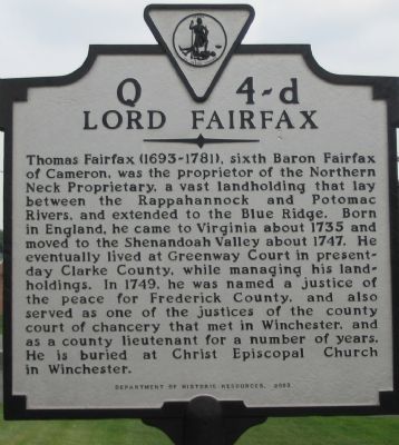
All of the counties along this route once belonged to the Proprietorship of Lord Fairfax. Thomas Fairfax, 6th Lord Fairfax of Cameron (+1781AD), was the inheritor of a vast proprietary claim that included the colony of Virginia north of the Rappahannock River. This had been a gift to loyal supporters of King Charles II, and Fairfax's mother, a Culpeper, had come into possession of the bulk of the territory. It was this family that employed the Carters as land agents in Northern Virginia. When Lord Fairfax, born in 1693AD at Leeds Castle in England, inherited this holding, he was not a disinterested proprietor, but actually visited Northern Virginia in the 1730s, moved to Belvoir on the Potomac with his cousin in 1747, and established his residence in the Shenandoah Valley at Greenway Court in 1752. This bachelor peer was a benevolent proprietor who was willing to work with his subjects when it came to their property taxes, at least more willing than the government of the colony. Fairfax County would be named in his honor in 1742AD (formed from Pr. Wm. Co.). While he remained loyal to the crown during the Revolution, he was well respected enough to be left alone. He died in 1781 at a ripe old age.

Map of the Northern Neck Proprietorship, 1736/1737.
The Proprietorship of the Northern Neck was dissolved with the Revolution, but his private lands remained in the control of his heirs -- who sold them to a group of gentlemen led by John Marshall, who would become chief justice of the Supreme Court.
I present then, a couple of shots of the tomb of Lord Fairfax himself in Winchester, Virginia.


Only a couple blocks away is the very heart of the City of Winchester -- a city that was a frontier town and military staging point during the French and Indian War (Seven Years' War) in the 1750s.

Aside from the lovely pedestrian area downtown, Winchester is also the home of the old Frederick County courthouse. Frederick was one of the two original Virginia counties formed west of the Blue Ridge. An example of the architecture of the city is this, the Godfrey Miller home, built in 1785 and located downtown (cf., http://www.hmdb.org/marker.asp?MarkerID=60607):

On our journey, passing as we did from the Virginia Piedmont into the Shenandoah Valley of Virginia, we had, of necessity to cross the Blue Ridge mountain. We did so at the Ashby Gap. Ashby Gap happens also to be the point where the boundary line between the County of Loudoun and the County of Fauquier, Virginia ends -- beginning at the headwaters of the Bull Run to the east. That spot was originally marked by, as the colonial law forming the new county put it: "from the head of the main branch of Bull Run, by a straight course to the Thorough-fare of the Blue Ridge of mountains, known by the name of Ashby's Gap." The point in Ashby Gap where this line was to begin was originally marked by a tree. Now, you find the convergence point of Loudoun, Fauquier, and Clarke Counties, Virginia marked by this stone (the ridge also marks the eastern edge of Valley counties such as Clarke). US 50 and 17 come that close to entering Loudoun County!

No comments:
Post a Comment